Had American poet Robert Frost driven a Polaris Ace, the classic poem “The Road Not Taken” may have become “The Poem Not Written.”
You see, Frost, in his journey through the forest, came to a fork in the road:
Two roads diverged in a yellow wood,
And sorry I could not travel both
And be one traveler, long I stood
And looked down one as far as I could
To where it bent in the undergrowth;
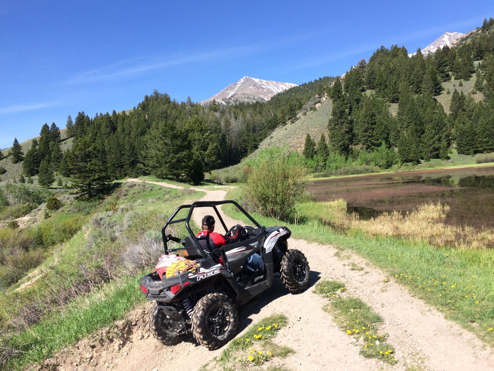
We had the same situation occur on a recent ATV ride where the Eight Mile Trail reached a fork—one heading north, the other south. Both looked inviting as they disappeared into the base of the Lemhi Mountain Range in eastern Idaho.
In Frost’s day, there was not time in the day (or maybe in a lifetime) to travel both roads. Good thing for us we had Polaris Ace ATVs and full fuel tanks.
We had parked our truck and trailer near Birch Creek just off of Idaho Highway 28 that runs from Mud Lake, ID, to Salmon, ID. Just west of Mud Lake, is the southern end of the Lemhi Mountain Range that runs about 100 miles north to Salmon, ID. At first glance, you see some high jagged peaks reaching up to 12,000 feet elevation that separates Birch Creek Valley on the east with the Little Lost River Valley on the west.
The Lemhi Range also separates the Caribou-Targhee National Forest on the east from the Salmon-Challis National Forest on the west. Distance-wise, each trail was only about 10-12 miles long but traversed some rugged terrain with elevations climbing from about 5,700 feet to well over 9,500 feet. We were going from one valley to the other … right over the top of the Lemhis.
Between the two valleys are also dozens of ATV trails that wind their way into some of the higher remote locations. A few of the trails feature small loop routes. But for the most part they come to abrupt halts due to impassable terrain.
However, at the trailhead of Eight Mile Road, two trails divide—both going over the top of the Lemhi Range and connecting with trails that came out from the Little Lost River Valley.
Then took the other, as just as fair,
And having perhaps the better claim,
Because it was grassy and wanted wear;
Though as for that the passing there
Had worn them really about the same,
Making this trek by means of anything other than motorized vehicle would require a lot of time and effort. But with the Ace … a single cockpit-seat ATV introduced by Polaris three years ago and designed to navigate tight, twisty trails with a 50-inch width restriction ... not only could we explore the trails in just a matter of hours, but we could also enjoy some of the side trails leading to incredible vistas.
After previously researching the trails in the area, and with some previous knowledge from hunting the west slope of the Lemhi Range, we determined that we could take the Pass Creek Trail (026) up to where it junctions with the Uncle Ike Trail (4341). And then, taking Uncle Ike out to the Little Lost River Valley, we could skirt the valley floor to the south for about three miles and pick up the North Fork Trail (4209) that climbs back over the top and ties into the Eight Mile Canyon Road Trail (022).
Time To Ride
Parking our vehicle just about a mile from Idaho Highway 28 at Birch Creek, we unloaded the Aces and started down Eight Mile Road (1739) for about seven miles until we reached the Eight Mile trailhead … or as Robert Frost said “two roads diverged in a yellow wood.”
Taking the right fork (026) we started to climb up a narrow canyon on a designated ATV trail. About a mile up the trail we came to another split. The left fork (025) was a more direct rout to the Uncle Ike Trail (4341). The right fork (026) went over to Pass Creek Lake and tied into South Fork Pass Creek Trail (045).
Since we had time to explore, we headed right (to the north) and over to Pass Creek Lake. There we picked up Trail 025 and looped on up to Uncle Ike. The first section of 026 was rocky with quite of few “up and downs” as you make your way across some mountain ridges to Pass Creek Lake. But once you head back southwest up the drainage, the terrain gets a little sandier and softer until you come out at the top of Uncle Ike.
Keep in mind that throughout this stretch of trails, you are constantly in and out of trees, up and down ridges and twisting your way across the mountain. You are constantly gaining and losing elevation, yet never actually getting to the top of the tallest peaks. And along the way you see natural scenery that reminds you how spectacular Earth really is. (We couldn’t go a half mile without stopping to take pictures of rock formations, crystal clear creeks, wildlife or breath-taking views.)
There were quite of few single and double track trails (some were clearly marked closed and therefore should not be used). This is where you’re going to need your National Forest Service map to know what’s open and what’s not. (Keep in mind there are a bunch of different regions and different maps. Be sure to pick the one that covers the right forest district.)
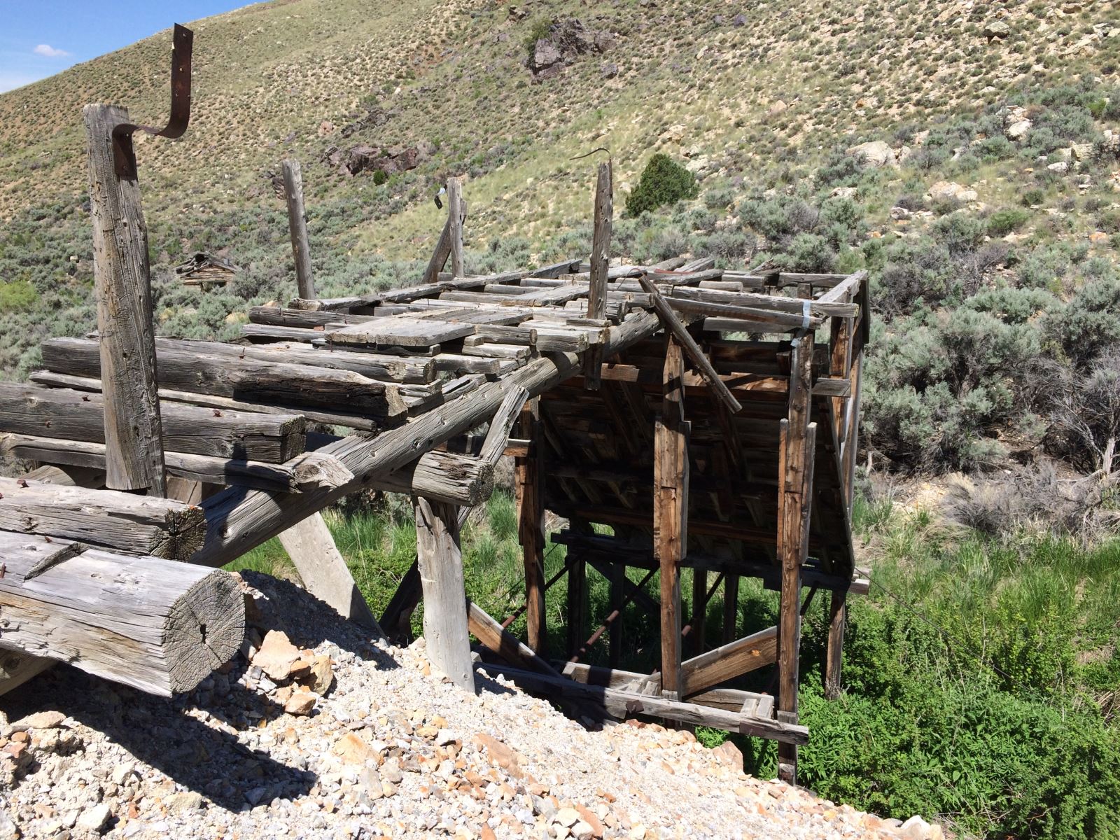
Once we picked up the Uncle Ike Trail (4341), we began our descent down the west slope of the Lemhi Range and into the Little Lost River Valley. When you descend out of the canyon at the mouth of Uncle Ike, there are access roads that parallel the mountain range. We headed south for about three miles until we came upon the North Creek Road. Then turning back to the east on the road, we followed it back into the mouth of the North Creek Canyon where we passed by an old mining site to Trail 4209 up North Creek. (There is a ranch house at the end of North Creek Road. Be sure take the jeep trail that veers to the south of the house so you don’t end up in somebody’s garage.)
And both that morning equally lay
In leaves no step had trodden black.
Oh, I kept the first for another day!
Yet knowing how way leads on to way,
I doubted if I should ever come back.
No need to wait another day (or so we thought). Even with all our side trips and stopping for photos, we still had plenty of time to explore the other route. We had traveled 25 miles (a third of those on side trips to enjoy scenic views).
The trail (4209) up North Creek is not nearly as rocky as Uncle Ike … but it still is rocky. You cross through North Creek several times as you ascend back up the Lemhi Range.
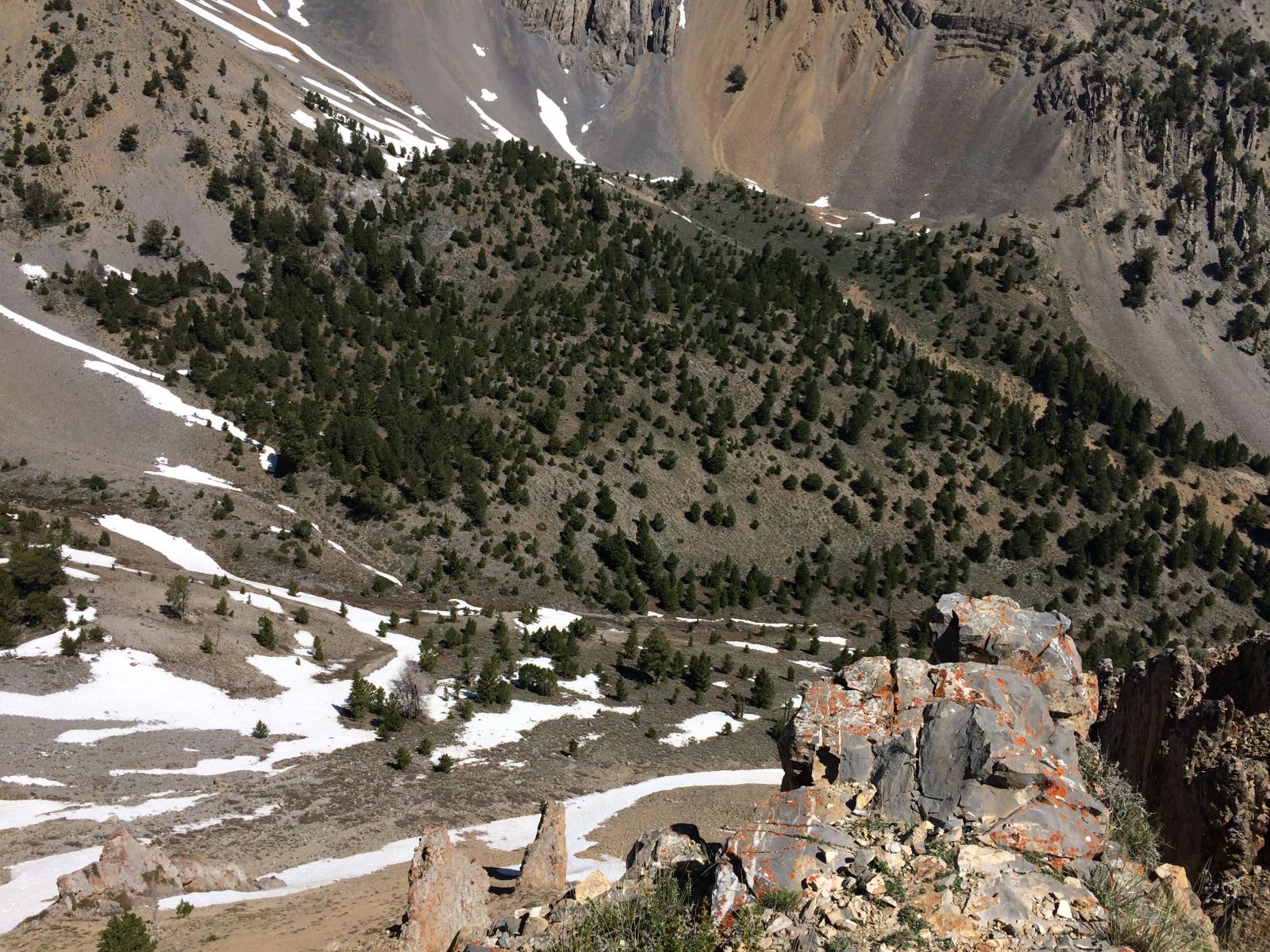
Between 2-3 miles up the canyon the trail takes a hard left turn and then starts twisting its way back and forth up the mountain nearly 2,000 feet where it skirts a sidehill across a shale rock path and into the upper part of Mormon Gulch (between Uncle Ike and North Creek).
This is one of the more scenic trails you’ll find anywhere. It’s not so steep that it scares you to look over the edge … but it’s steep enough to remind you that if you make a mistake, your ATV will be scattered all the way down a mountain.
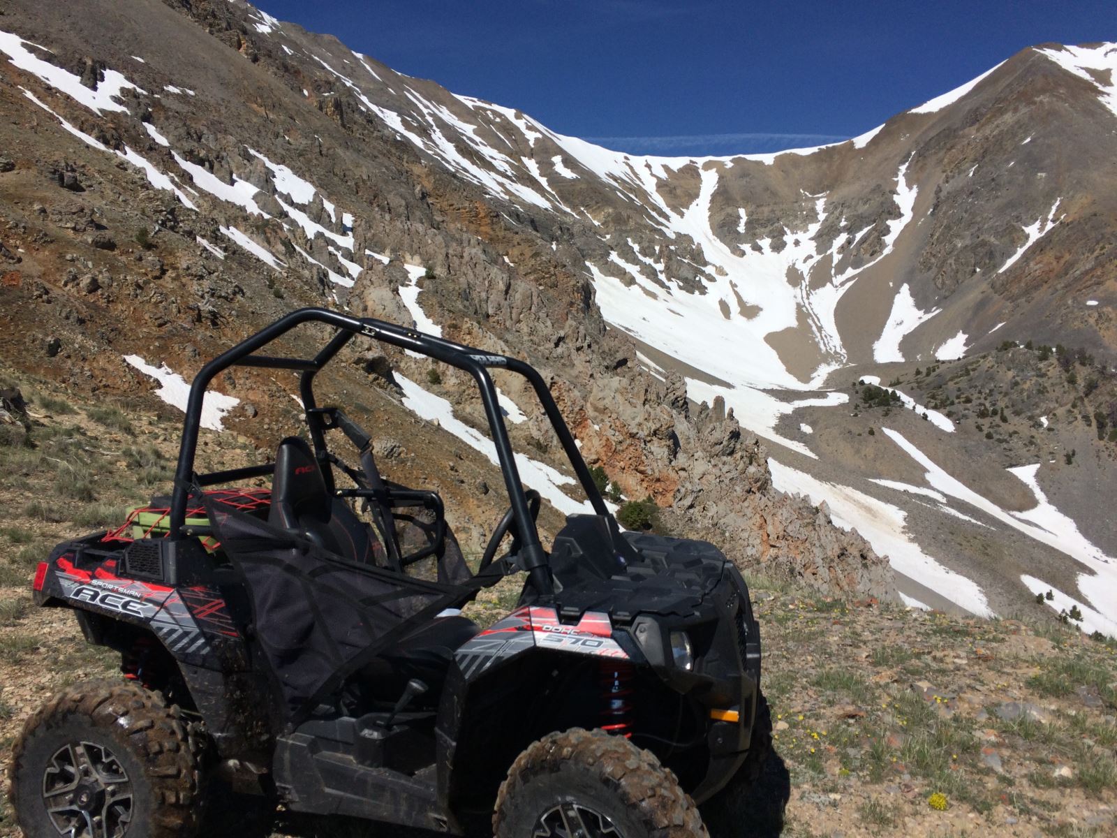
Just before you drop into Mormon Gulch, there’s another scenic overlook that allows you to see up and down the Little Lost River Valley. You’re at 9,517 feet elevation here … looking up with still more than 1,000 feet of mountain above you.
After exploring a few short stem trails in Mormon Gulch, we finally picked our way to where the North Creek Trail (4209 turned into the Eight Mile Trail (022). Here we could get to the top of the ridges and look down into the Birch Creek valley and see as far east as the Teton Mountains in Wyoming.
Decision Time
Although we had hit patches of snow in the higher elevations along the way (this was a June ride), and several times we needed to rely on 4-wheel drive, for the most part this ride didn’t reach the classification as “extreme.”
However, as we started to descend into Eight Mile Canyon, it was apparent that there were still parts of the mountain that needed more sun to melt the snow … and we were riding through them.
Within two tenths of a mile we dropped 200 feet in elevation and had to bust through a dozen small snow drifts as we descended into a north-facing canyon. We reached a point in the trail where we knew if we dropped another 10 yards, we would be committed to going down. Yet there was a snow drift up to six feet deep that covered about 200 yards of trail … and we couldn’t see around the next corner to know if the drifts continued. But that was irrelevant since it looked as though the depths of the snow would likely leave our Aces high centered and the terrain was so steep that there was no way to avoid the drifts on an ATV.
We either had to commit to going down (and risk walking out off the mountain) or turn around and retrace our tracks back to Uncle Ike and return the way we came. And not knowing how far it was to the trailhead (how far we would have to hike out), it just made more sense to avoid unnecessary work and add a few more miles to our ride.
It was 2:30 p.m. (daylight wasn’t an issue) and we had 38 miles on our odometer (fuel wasn’t an issue). It had taken us about five hours to get to where we were. But without any side trips or stopping for photos, we figured it would take us less than two hours to get back.
Time To Make Tracks
By 4 p.m. we had retraced our route and pulled into the trailhead at Eight Mile. The direct route back (no side trips) was only 22 miles. And since we made such good time, we figured we had enough daylight and fuel to take Trail 022 south to see how close we had come to completing our loop.
The first thing we learned about Trail 022 is that there are rocks—even more so that up Uncle Ike. And this trail climbs in elevation—about 4,000 feet in three miles.
We were about 2.5 miles up the trail when we started to get into the snow drifts. One thing about breaking drifts going uphill … even if you get stuck gravity will help you get back out. (Gravity can become your enemy if you get stuck going downhill.)
Time and time again we had to pound through drifts. We had an Ace 570 and an Ace 900. We found that the 900 had better power to break open a drift and the 570 could then follow the tracks.
But eventually we got to a point where the drifts where just too deep to bust through. We were nearly three miles up the trail but we couldn’t get to the next turn of the trail which was about 30 yards in front of us. So we decided to leave our ATVs and walk to the next bend in the trail. There we were at the base of the 200-yard snow drift we had seen from the top.
Only 250 yards of trail had stopped us from completing our circle. But it also served as an invite to come back in a couple of weeks after Mother Nature works her warmth on the remaining snow.
By the time we returned to our truck we had logged 74 miles on a loop that could be completed in about 25 miles (if you take no side tours). But when you see this country, it’s almost impossible to not stick your nose into a few of the branched trails to see where they go.
I shall be telling this with a sigh
Somewhere ages and ages hence:
Two roads diverged in a wood, and I—
I took the one less traveled by,
And that has made all the difference.
Sidebar
Trail Map Tips
Although most will want a good trail map to show the route, we found that if you know where you want to go and mark the various trail numbers on a small sticky note, you don’t need to be constantly stopping to pull out your map to see what trail to take.
I had marked my trails in order that I would encounter them, including a short description of what the trail is. This saved time and gave us confidence that we were making the correct turns.
Notes from recordings
I had my little sticky note to tell me what trails to take.
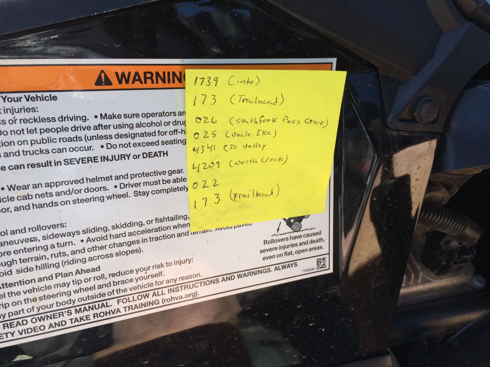
1739 (8 Mile Road)
173 (At end of road trailhead)
026 (We did the South Fork Pass Creek Loop to Pass Creek Lake)
025 (Headed back to the Uncle Ike trail)
4341 (Uncle Ike trail out to the Little Lost River Valley)
Now it was a matter of following dirt roads back to the south to pick up the North Fork Road that would take us to …
4209 (North Fork Trail)
022 (North Fork Trail turns into the 8 Mile trail)
073 (Back at the trailhead and completing the loop)
(Sidebar on how a sticky note lets me not have to stop to pull out a map at each trail junction.)
Recorded notes:
1—Trailhead at 8 Mile. It’s 7.7 miles from where I parked the truck and about 9 miles from Highway 28. We’re at the split (trailhead of 8 Mile) where trail 026 goes west (toward Uncle Ike and Pass Creek) and 022 comes in from the south (from North Creek).
2—Just finished the first section where we took 026 up and over to Pass Creek Lake. The first part of the trail coming out of 8 Mile is tight and twisty with a rocky base for the most part. Once we got to the lake and turned on 025 the trail became a little more open with more of a dirt base. Throughout both sections we were in and out of trees. Once we got to the Uncle Ike Trail Junction we were pretty much in the upper basin area. There were still mountains above us and some stem trails that would take you up ridges were you could get some incredible views.
Here we could either head back east and loop on down to where the Pass Creek Trail spits and on down to the trailhead, or we could head west and drop down Uncle Ike to the Little Lost River Valley. Our plan was to drop down Uncle Ike, skirt the valley and turn back up North Creek to make a bigger loop.
There were quite of few single and double track trails (some were clearly marked closed that should not be used). This is where you’re going to need your Salmon/Challis National Forest Service Map to know what’s open and what’s not. (Keep in mind there are a bunch of different regions and different maps. Be sure to pick the one that covers the right district.)
3—Took a side route that took us up to elevation 9550 that took us to the top of Pass Creek to a big mountain bowl with a severe drop off. The trail was up several rocky ridges and through a few snow drifts (yes, snow drifts in June). What a spectacular view.
4—At Uncle Ike/Pass Creek intersection, we had covered 17 miles (with a few very short side trips). Once we het the Little Lost Valley at the bottom of Uncle Ike, our odometer was at 22 miles. Then heading across the dirt roads the skirt the valley, we were 25 miles on the odometer where we tied into the North Fork road, about a mile from the trailhead.
5—Reminder, when you get to North Creek Road, you will head back east about a quarter mile and there will be a house at the end of the road. Just before the house a jeep road peels off to the right and continues east up into the mouth of the canyon. You will drive right through an old mining area with structures and mining tailings before you start up into the canyon trail.
6—At 9,517-foot elevation we’re at the top of North Creek. We took a side trail about a quarter mile to where we could look down into the Little Lost River Valley. The trail up North Creek featured a lot of switchbacks up the face of a mountain and across several rock shale slides. But the views were breath-taking. This is high elevation and great riding … a good place to stop for lunch and enjoy God’s great creation.
7—At the top of North Creek Trail (4209) it turns into Trail 022 and starts its descent down toward 8 Mile. With all the added side trips, we are at 38 miles on the odometer. We started getting into a few more snow drifts and where the trail drops down into a steep canyon in the trees, the drifts were getting bigger and more frequent. The trail descends rather quickly, and the question as too whether we could make it down through the drifts started raising a little concern. There was also some concern as too whether we could even make it back out through the drifts we’ve already gone through (going through a drift downhill is a lot easier than going through it uphill.)
We were at a point were we could see about 250 yards ahead of us—200 of those yards in one massive snow drift, remnants of snow sloughing down the steep slopes and settling on the trail—about 3-6 feet deep. And even if we could beat that drift, we couldn’t see around the next corner to know if it would be getting any worse. We were near the elevation where the snow had to start thinning out altogether … but being the first time on the trail, we just didn’t know.
We weren’t looking for a big fight, nor did we have the desire to walk off the mountain. It was already 2:30 p.m. and we knew we had to make a decision. Our option was to continue the fight, backtrack our loop. We chose the latter. Although it was a fight back up through a few drifts, we were soon on our way back down North Creek, over to Uncle Ike and on down to 8 Mile.
The back loop (with no side trips) was 22 miles around to the trailhead. We made good time (five hours to go over, one hour to come back) and we were very curious how close to the end of trail 022 we had come. So we stuck our nose back up 022 until we hit snow.
Now 022 gains elevation like you wouldn’t believe (about 2,700 feet in less than five miles). The trail is rocky with some tight switchbacks. Quite a few sections required riding in 4-Low as we crawled over rock slides. After busting a dozen or so drifts, we finally reached the point where we couldn’t climb any farther without spinning out and high-centering our Polaris Aces in the snow. We walked about 20 yards to the next turn in the trail only to find the 200-yard drift that deterred our original descent. We were only 3.5 miles from the trailhead.
By the time we returned to our truck we had logged 74 miles on a loop that could be completed in about 25 miles if you take no side tours. But when you see this country, it’s almost impossible to not stick your nose into a few of the branched trails to see where they go.
Elevations—We started at 5700 feet elevation by Birch Creek just of Highway 28 north of Mud Lake, ID. Several times we climbed over 9,500 feet. When we came out of Uncle Ike in the Little Lost River Valley, we were at about 6,000 feet. The mountain peaks in the area reached as high as 11,000 feet. We were constantly in and out of Cell service … but all you had to do was climb a ridge to get reception.
I shall be telling this with a sigh
Somewhere ages and ages hence:
Two roads diverged in a wood, and I—
I took the one less traveled by,
And that has made all the difference.